| |
|
Dies ist eine alte Kopie des GenWiki und spiegelt den Stand vom 8. Mai 2022 wider. This is an old copy of the GenWiki and reflects the status as of May 8, 2022. Please visit us at wiki.genealogy.net |
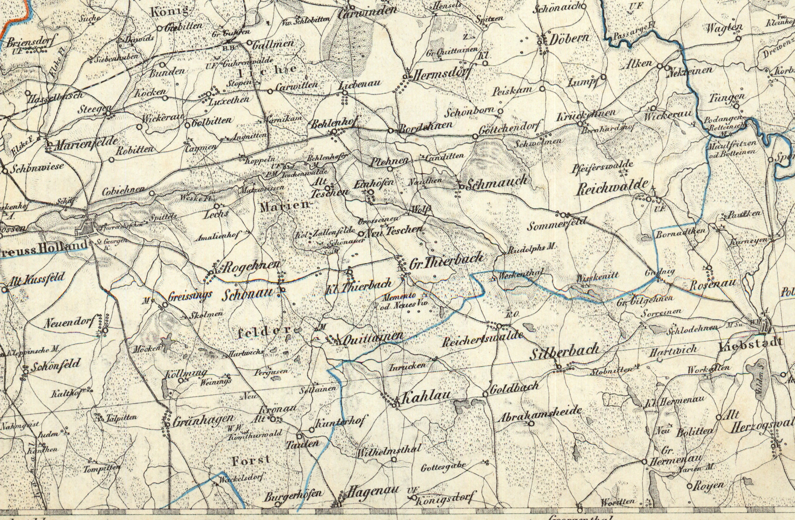
Datei:Reymanns Special-Karte 19 Heilsberg Pr HOll.jpg
aus GenWiki, dem genealogischen Lexikon zum Mitmachen.
Größe der Voransicht: 800 × 524 Pixel
Version in höherer Auflösung (2.534 × 1.660 Pixel, Dateigröße: 3,08 MB, MIME-Typ: image/jpeg)
Dateiversionen
Klicke auf einen Zeitpunkt, um diese Version zu laden.
(Letzter | Erster) Zeige (nächste 50 • vorherige 50) (20 | 50 | 100 | 250 | 500)| Version vom | Vorschaubild | Maße | Benutzer | Kommentar | |
|---|---|---|---|---|---|
| aktuell | 18:46, 22. Jan. 2014 | | 2.534×1.660 (3,08 MB) | Geraldraq | (==Beschreibung== {{Information |Beschreibung =Ausschnitt Preußisch Hollannd aus der Reymanns Spezialkarte Nr.19 Heilsberg |Quelle = http://igrek.amzp.pl/1760803 |Urheber = Reymann |Datum = um 1800 |Scans =http://www.mapywig.org/m/German_maps/series/200K_) |
Dateiverwendungen
Mehr als 100 Seiten verlinken auf diese Datei. Die folgende Liste zeigt nur die ersten 100 Links auf diese Datei. Eine vollständige Liste ist verfügbar.
- Preußisch Holland
- Warnikam
- Sorrehnen
- Gillgehnen (Landkreis Mohrungen)
- Hartwich
- Schodehnen
- Gudnick (Landkreis Mohrungen)
- Silberbach (Landkreis Mohrungen)
- Stobnitt
- Alken (Landkreis Preußisch Holland)
- Alt Kußfeld
- Alt Teschen
- Angnitten
- Bordehnen
- Briensdorf
- Bunden
- Döbern (Landkreis Preußisch Holland)
- Göttchendorf
- Greißings
- Groß Thierbach (Landkreis Preußisch Holland)
- Grünhagen (Landkreis Preußisch Holland)
- Hasselbusch (Landkreis Preußisch Holland)
- Hermsdorf (Landkreis Preußisch Holland)
- Kalthof (Landkreis Preußisch Holland)
- Karwitten
- Kopiehnen
- Krickehnen
- Krönau (Landkreis Preußisch Holland)
- Lägs
- Liebenau (Landkreis Preußisch Holland)
- Lomp (Landkreis Preußisch Holland)
- Luxethen
- Mäken (Landkreis Preußisch Holland)
- Marienfelde (Landkreis Preußisch Holland)
- Nauten
- Neuendorf (Landkreis Preußisch Holland)
- Neu Teschen
- Peiskam (Landkreis Preußisch Holland)
- Pergusen
- Pfeiffertswalde
- Plehnen (Landkreis Preußisch Holland)
- Quittainen (Landkreis Preußisch Holland)
- Reichwalde (Landkreis Preußisch Holland)
- Robitten (Landkreis Preußisch Holland)
- Rogehnen (Landkreis Preußisch Holland)
- Schmauch
- Schönborn (Landkreis Preußisch Holland)
- Schönfeld (Landkreis Preußisch Holland)
- Schönwiese (Landkreis Preußisch Holland)
- Sommerfeld (Landkreis Preußisch Holland)
- Steegen (Landkreis Preußisch Holland)
- Zallenfelde
- Groß Quittainen
- Gut Guhren
- Nektainen
- Klein Wickerau (Landkreis Preußisch Holland)
- Bernhardshof (Landkreis Preußisch Holland)
- Schwöllmen
- Vorwerk Peiskam
- Rudolfsmühle (Landkreis Preußisch Holland)
- Gut Gillgehnen
- Weeskenitt
- Teschenwalde (Landkreis Preußisch Holland)
- Vorwerk Memento
- Klein Thierbach
- Einhöfen
- Grossainen
- Kanditten (Landkreis Preußisch Holland)
- Amalienhof (Landkreis Preußisch Holland)
- Hartwichs
- Schönau (Landkreis Preußisch Holland)
- Mühle Behlenhof
- Behlenhof (Landkreis Preußisch Holland)
- Podangen
- Stöpen (Landkreis Preußisch Holland)
- Giebitten
- Gut Davids
- Koken (Landkreis Preußisch Holland)
- Siebenhufen (Landkreis Preußisch Holland)
- Wickerau (Landkreis Preußisch Holland)
- Golbitten (Landkreis Preußisch Holland)
- Kaymen (Landkreis Preußisch Holland)
- Koppeln
- Vogtshof
- Köllming
- Komthurhof
- Taulen
- Solainen (Landkreis Preußisch Holland)
- Kanthen
- Buchental (Juden)
- Talpitten
- Schäferei (Weeskenhof)
- Nahmgeist
- Preußisch Holland/Reymann Karte 2
- Tompitten
- Weinings
- Skollmen
- Matzweißen
- Komthurwald
- Wirtshaus Vogelsang

